Written
10 Oct. 2006. Last Updated April
2014.
This paper has been
adapted from a biography of Dr Neville Yeomans.
THE LAY OF THE
LAND
This
paper discusses Australian Dr Neville Yeomans life experiences that guided and
informed his evolving of the Fraser House therapeutic community psychiatric
unit in 1959 in North Ryde, Sydney, NSW and his later outreach. Dr Yeomans
(1928-2000) was a psychiatrist, psychologist, sociologist, Biologist,
Barrister. The precursors of Yeomans’
way of thinking, processing and acting are traced firstly to the pioneering
work of Neville’s father Percival A. Yeomans (supported by his three sons), who
was described by the world famous English agriculturalist Lady Balfour in the
1970’s as the person making the greatest contribution to sustainable
agriculture in the past 200 years (Mulligan and Hill 2001, p. 194). The chapter details the influence on
Nevilles father’s evolving of Keyline, a set of processes and practices for
harvesting water, generating new vibrant topsoil and creating sustainable
agriculture. It also traces the influences on Neville Yeomans and his father of
their relating with Australian Aboriginal and Islander people. As well
Neville’s East Asia influences are discussed.
INSPIRING TRAUMA
Neville’s
traumatic incidents discussed in Chapter One also had a profound, though different
impact on his father P.A. Yeomans, (Mulligan and Hill
2001, p. 193). As
mentioned in Chapter One, three-year-old Neville became lost in West Queensland
desert country and was found by an Aboriginal tracker. At the time when Neville
was lost Neville’s father was a mine assayer and a keen observer of landscapes
and landforms. Neville’s
father was deeply impressed by the Aboriginal tracker’s profound
knowledge of the minutiae of his local land; in that harsh dry rocky climate
with compacted soils, the tracker had such an intimacy with the landscape that
he was not relying on following footprints. For example, he would notice minute
traces left as evidence of the movements of a little boy that would not be made
by other creatures or natural phenomena – such as the way soil grains were on a
dead leaf contrary to the prevailing breeze.
The
other thing was that upon finding little Neville, the tracker was so intimately
connected to the local land and its form, he knew exactly where to go to find
water. It was not that this tracker knew where a creek or a water hole was, as
there was no surface water.
The
tracker knew how to find water whenever he wanted it, and wherever he was in
his homeland. He and his people ‘be long’ there (40,000 plus years).
They were an integral part of the land. They were never apart from it. The
tracker was ‘of the land’. He and his community saw the Earth as a
loving Mother that provided well for them continually.[1]
As soon as the tracker found Neville, he had to find the right kind of spot for
a short easy dig. Because of Neville’s dehydration, the tracker needed water
for Neville fast. He used his knowledge of his place and quickly had Neville
sipping water. Mulligan and Hill report about the incident where Neville was
lost:
According
to Neville, it was probably this incident that gave his father his enduring
interest in the movement of water through Australian landscapes, because he
could see that an understanding of this would be a huge advantage for people
living in the driest inhabited continent on Earth (2001, p. 193).
WATER TELLING US
WHAT TO DO WITH IT
In the
years after leaving mine assaying, P.A. Yeomans had moved on to having his own
earth-moving company. P. A. had just purchased the Nevallan (from Neville and
Allan) and Yobarnie (from Yeomans and Barnes) properties in Richmond, NSW with
his brother-in-law Jim Barnes in 1943 - a year before the bushfire where Neville
saw his Uncle Jim Barnes burn to death. North Richmond is on the Hawkesbury
River a little over two hours inland from Sydney
P. A.
emulated the Aboriginal tracker in becoming familiar with the landform of his
two properties. P.A. wanted to store or use all of the water that landed
on the properties. P.A. wanted to be able to water his two properties so they
were so lush and green all year round, they would be virtually fireproof. When the
families acquired the properties the soil was ‘low grade’. It was undulating
hill country with plenty of ridges that were composed of low-fertility shale
strewn with stones. The following photo taken at Nevallan, one of the Yeomans’
farms shows the original poor shale and rock ‘soil’ throughout the two
properties when the properties were acquired.
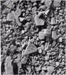
Photo 1. The low fertility shale
strewn with stones on P.A.’s farm - from Plate 30 in
P.A.’s book ‘Challenge of Landscape’
– used with permission (Yeomans 1958b;
Yeomans 1958a)
Photo 2
shows a spade full of fertile soil after two years of the processes evolved by
P.A. and his sons. To clearly show the difference in the soil, a clump of the
fertile soil has been placed beside earth on the base of a tree stump that
became exposed when the tree fell over. This lighter low-grade soil had not
been involved in the processes the Yeoman’s evolved.
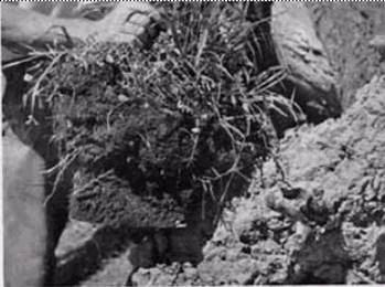
Photo 2. Fertile soil after two
years compared to the original soil - a copy of Plate
30 in P.A.’s book ‘Challenge of Landscape’ - Used with permission
Within three years, Yeomans and his sons
had energized what conventional wisdom said was impossible; they had altered
the natural system so that the natural emergent properties of the farm, as
‘living system’, created ten centimetres (4 inches) of lush dark fertile soil
over most of the property (Yeomans and Murray Valley Development League 1974). What is important is that the local
natural ecosystem did the work. P.A. enabled emergent aspects in nature to
self-organize towards increased fertility. With the interventions that P.A.
introduced, the property became lush and green twelve months of the year. It
was virtually fireproofed!
The
balance of this chapter will specify the processes the Yeomans evolved and
applied on their farms and the Indigenous precursors they drew upon. It then
briefly introduces the ways Neville evolved in adapting his family’s farming
processes relating to the natural life world to evolving change in the social
life world.
Keyline Emerges
Over
thousands of years, if this continent’s Aborigines wanted to spear fish in the
shallow creeks and rivers, they would copy the behaviour of the wading birds
that wade slowly, and then react extremely fast with their long beaks. The
Aboriginal hunter with his spear mimics these waders. Resonant with the
continent’s Indigenous ways, P.A. and his sons engaged in bio-mimicry - letting
the water, the landforms, the soil biota, and the balance of the local
eco-system tell them what to do. Neville told me (July 1998) that P.A. would
take Neville and Neville’s younger brother Allan out onto the farms as they
were growing up, whenever it rained, so they all could learn to see directly
how the rain soaked in at different times, how long before run-off would occur
on different land forms, and what paths down the slopes the run-off moved on
different land shapes. Like the continent’s Aborigines, they were learning to
have all of their senses focused in the here-and-now, attending to all that was
happening in nature. As action researchers, they became connoisseurs of their land and all life on
it (Eisner 1991, p. 176).
The Yeomans were being informed by landform
and able to make very fine discriminations. Whatever action P.A. and his sons did, they
always observed how nature responded. P. A. obtained contour line maps of his
property with a useful scale to further aid his understanding of landform.
According to Ken Yeomans (P.A.s third and youngest son) in an October 2003
phone discussion, the map scale was typically 1 in 25,000 with 5 metre contours.
Neville said that his father constantly referred to the three primary landscape features - the main ridge
(elevated from the horizontal), the primary ridge (lateral to the main ridge)
and the primary valleys (lateral vertical cleavages). The farm was perceived by
P.A. as a cleavered unity, a feature pervasive in nature. P. A.
discovered where the best places were to store run-off water for maximum later
distribution using the free energy of gravity feed. It was high in a special
place in the primary valleys. Overflow from dams high in the primary valleys
were linked by gravity-based over-flow channels to lower dams. Below is a succinct statement written by
P.A. Yeomans about what he called ‘Keyline’. It is from P.A.’s speech at the UN
Habitat ‘On Human Settlements’ Forum in Vancouver, Canada during 27th May to 11th June 1976. P.A.’s speech was entitled ‘The Australian Keyline Plan for the Enrichment of Human Settlements’ (1976, p. 5-6).
Keyline relates to a special feature of
topography namely, the break of slope that occurs in any primary valley.
Primary valleys are the highest series of valleys in every water catchment
region and lie on either side of a main or water divide ridge. They are widely
observed as the generally smooth or grassed over valleys of farming and grazing
land but are often overlooked and disguised in the city. On either side of the
primary valley is a primary ridge. Of the three basic shapes of land, namely,
main ridge, primary valley and primary ridge, the primary valley shape occupies
the smallest area of land and the primary ridge shape, the largest. In the
rural situation irrigation is a matter of watering the large primary ridge
shapes, even on land which appears flat.
All of the structures, processes and
practices that P. A. Yeomans evolved he also called Keyline (Yeomans, P. A. 1971b; Yeomans, P. A. 1971a). Yeomans first outlined his ideas
about water movement and how to detect Keypoints in a book entitled, ‘The
Keyline Plan’ (1954). The books,
‘Challenge of Landscape’ (Yeomans 1958a), ‘Water for Every
Farm’ (Yeomans, P. A.
1965), and
‘The City Forest : The Keyline
Plan for the Human Environment Revolution’ (Yeomans, P. A.
1971a)
followed. Three of P.A.
Yeomans’ books, ‘The Challenge of Landscape’ (Yeomans 1958b), ‘The Keyline Plan’ (Yeomans, P. A.
1955), and the ‘City Forest’ (Yeomans, P. A.
1971b), including all of their diagrams and
photos, are now on-line on the Internet through the Soil and Health
Organization. In 1993, Ken Yeomans, Neville’s younger brother published his
book, ‘Water for Every Farm: Yeoman’s Keyline Plan’ (Yeomans and Yeomans 1993). This book clarified some aspects of
Keyline.
Diagram
1 below shows the main ridge (the dotted line along the left), two primary
ridges and two primary valleys. A Keyline and a Keypoint only occur in primary
valleys and each primary valley has only one Keyline and Keypoint. One Keypoint
is shown in the diagram. The other Keypoint is on the Keyline towards the top
of the diagram (where it crosses the flow line shown as a dotted line). Note
that the Keypoint is on the primary valley flow line on the contour above the
first wider gap between the contours.
The
flow line is marked on Diagram 1 below as the dotted line through the Keypoint.
This wider space between contours indicates less steepness on the slope. The
dotted line along the primary ridges in the diagram below is the water divide
line which, other things being equal divides the flow of water into one or
other of the primary valleys on each side of the primary ridge. The dotted line
along the main ridge is also a water divide line.
Allan (Dec 2005)
pointed out that the diagram below shows that the contours above the Keyline
are closer together at the valley flow line above the Keypoint and get wider
apart as these contours go around the ridges on both sides of the valley. The
reverse is the case below the Keypoint. The contours are wider apart on the
flow line below the Keypoint and come closer together towards the ridges on
both sides of the valley. The point where the contours are closest is the
boundary between valley and ridge.
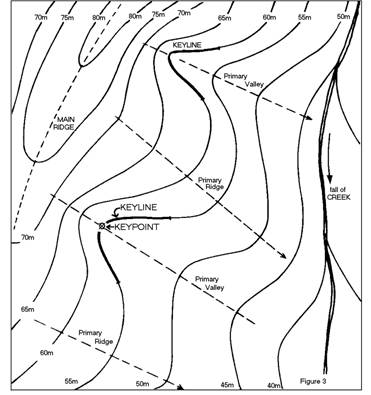
Diagram 1. The Three Keyline Features – Photo from P.A.’s UN Habitat Speech (1976, p. 9)
Above
the Keypoint is typically an armchair-shaped land form that directs the water
run-off so that most of it ends up arriving in an area that may be as small as
a square metre (the Keypoint) – sometimes the very start of the typical creek
as creek. P.A. found that the optimal locations for dams were at the Keypoint
on the Keyline in the respective Primary Valleys on his properties.
P.A.’s ‘On Human Settlements’
Forum speech contains another description of Keyline:
It will be observed that in the primary valleys the first slope falling from the ridge above is short and steep – usually the steepest slope in the immediate environs[2] – while the second slope is flatter, much longer and extends to the watercourse below. The point at which the change occurs between these two slopes is named the Keypoint; the Keyline extends on the same level on either side of this Keypoint and partly encloses a concave shape on the land. Only primary valleys have Keylines (see contour diagram above) (Yeomans, P. A. 1971b; Yeomans, P. A. 1971a; 1976, p. 7-8).
Ken Yeomans in a December 2005 email
referred to the above quote:
I question the technical accuracy of saying it ‘partially’ encloses
a concave shape on the land. Actually the Keyline occupies all of the concave
shape of the contour line curve.
The change of direction of the contour from concave through the valley
to the convex curve of the ridge defines the end of the
Keyline on either side of each primary valley.
Diagram
1 above shows Ken Yeomans point mentioned above - that the Keyline extends
either side of the Keypoint for a particular distance along the contour line
running through the Keypoint. P.A
then goes on in his On Human Settlements Forum Speech to give a key point
summary (1976, p. 9):
The Keyline is significant because:
1.
It is
the first place in any valley where rain run-off water, concentrated from the
higher slopes, can form a stream.
2.
It is
also the first place where run-off water disappears when the rain stops unless
the water is contained.
3.
It is
the highest possible storage site in any valley of the land.
4.
It is
often the highest point at which good construction material for earth dams is
available (higher up the earth may be less decomposed and less suitable for dam
building).
5.
It is
the essential starting point for a water control system in any landscape that
produces run-off; and
6.
It is
the line of change when the three shapes of the land merge and readily disclose
the geometry of land contours and the behaviour of surface flowing waters.
The Keyline is thus of major significance
to any concept that aims to enrich the environment by controlling and using all
available water. Note point six above - the Keypoint in nature is saturated
with information carrying capacity. On this typically square metre of land is
the junction of all three land forms. Information distributed through each
landform is present at the Keypoint. The Keypoint, for those with eyes to see,
is the place that reveals the interaction of water with land. There is a
confluence at the Keypoint of the water runoff from the main ridge above the
primary valley and adjacent primary ridges down the curved slope at the head of
the primary valley.
Lincoln and Guba made a similar point about
distribution of information within a system (quoted in Chapter Four):
Information is distributed throughout the
system rather than concentrated at specific points. At each point information
about the whole is contained in the part. Not only can the entire reality be
found in the part, but also the part can be found in the whole. What is
detected in any part must also characterize the whole. Everything is
interconnected (1985, p. 59).
The Yeomans’ genius was that they spotted
the information distributed throughout the three landform systems and saw how
the distributed information inter-connects and interacts at the Keypoint.
Keypoints are saturated with information that is distributed in the system.
Sensing and observing the Keypoint may reveal insights as to how the whole
complex dynamic system works.
Resonant with the above, as discussed in
Chapter Three, Neuman also makes the same observation that at each point in a living
system, information about the whole is contained in the part (1997, p. 433). Not only can the entire reality be found
in the part, but also the part can be found in the whole. What is detected in
any part must also characterize the whole. Everything is interconnected,
inter-dependent, inter-related and inter-woven. Also resonant with Yeomans and
Neuman, Joseph Jaworski (1998, p. 80) writes of a conversation with theoretical
physicist Dr. David Bohm:
We were talking about a radical,
disorientating new view of reality which we couldn’t ignore. We were talking
about the awareness of the essential inter-relatedness of all phenomena –
physiological, social, and cultural. We were talking about a systems view of
life and a systems view of the universe. Nothing could be understood in isolation,
everything had to be seen as a part of the unified whole.
Jaworski writes of Bohm saying that it’s an
abstraction to talk of nonliving matter:
Different people are not separate, they are
all enfolded into the whole, and they are all a manifestation of the whole. It
is only through an abstraction that they look separate. Everything is included
in everything else.
Yourself is actually the whole of mankind.
That’s the idea of implicate order – that everything is enfolded in everything.
While Jaworski
and Bohm were talking about a ‘radical, disorientating new view of reality’,
this view has been the natural view of Australian Aborigines since antiquity,
and it was this view that the Yeoman’s used to perceive inter-related things
that Western farmers had never seen before. Barabasi (2003) in his book ‘Linked - How Everything is Linked to Everything and What
it Means’ also explores the same theme.
Consistent with the foregoing, for the Yeomans, the
farm was a living system made up of interconnected, inter-related,
inter-dependent and interwoven living systems and associated inorganics. I have
been referring to this as ‘connexity’; Neville or the other Yeomans did not use
this term, although it connotes their understanding of system linkages well.
Where the context around a Keypoint made it possible P.A.
placed a dam wall some way below the Keypoint so that the dam could fill to
that Keypoint when it was full. He designed his farms Nevallan and Yobarnie to
fit nature. All of the dams were placed so as to simultaneously get water
run-off, pass overflow to a dam below by gravity, and by gravity-based
irrigation, pass on the water to the soil when desired. Neville (August 1998)
and Allan (May 2002) both confirmed that they were with their father at the
moment when they recognized what he called the Keypoint and the Keyline in
landform – the central concepts in Keyline (Yeomans 1955a, p. 118).
Allan
Yeomans in a phone conversation (December 2005) noted that the Keypoint and
Keyline in successive primary valleys along a main ridge have an ascending (or
descending) elevation as occurs in Diagram 1 above. Allan spoke of regular
patterns in nature; as an example, the Yeomans’ experience was that often the
height of the bottom of a dam wall below a Keypoint in a primary valley being
above the height of the top of the dam wall in the adjacent primary valley
(refer Diagram 1 above). This has implications for linking the two dams by
over-flow channel along a contour.
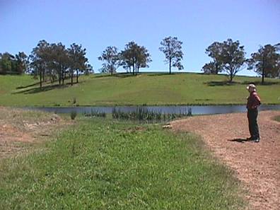
Photo 3. A Photo I took in July
2001 showing the dam’s overflow channel
The above photo shows the gentle slope on the overflow
channel of the dam shown in photo 4 below. There was no sign of erosion on this
channel even though this dam and the other Keyline structures on the property
had had no maintenance by the current landowner for over twenty years. A
noteworthy aspect of the farm is that before PA Yeomans commenced his work
there in the 1950s, the soil was regarded by agricultural experts who visited
the farm as being low-grade shale strewn with small rocks (as can be seen on
both sides of the Keyline channel). Some of the area where Keyline processes
were implemented is shown in the background ridge in the photo and the
processes have produced staggering increases in biomass – what conventional
wisdom says takes 800 years to produce. One researcher who had travelled the
world extensively, commented that after 3 years of Keyline process the new
earth generated was on a par with what he had seen in the fertile Nile Delta.
P.A. wrote:
Once the eye becomes trained to see these simple land
shapes, and the mind has selected and classified one or two, there is a
fascination in the continuous broadening of one’s understanding and
appreciation of the landscape (1958, p. 56).
The Social Ecologist, Stuart Hill and I visited Nevallan
for the first time in 2001 and I took Photo 4 below showing the place where
P.A. and Neville first spotted the Keypoint and Keyline. The very spot where
they realised the significance of the Keypoint is where the closest water is in
the closest dam in photo 3 below; the primary ridges are on the left and right
of the primary valley.
Like all Keypoints, the one in the photo is on the drainage
line. Photo 4 shows one of the primary ridges on the left near the top of the
primary valley. The Chapter One Photo 3 was taken looking up towards where the
photo below was taken. Stuart Hill, in Chapter Eight of his book on Australia’s
Ecological Pioneers, outlines some aspects of the process P. A. and his sons
used (Mulligan and Hill 2001, p. 193):
What
Yeomans senior discovered through such patient observation was that there is a
line across the slope of a hillside where the water table is closest to the
surface. The ground along this line looks wettest and is reflective when it
rains heavily.
It is
the line along which it makes most sense to locate the highest irrigation dams
within the landscape, because this is where the run-off water from above can
most effectively be collected and subsequently used at the most appropriate
time to irrigate the more gently sloping land below. Yeomans called this line
the Keyline.
Photo 4. Photo I took during July
2001- looking down towards the Keypoint at the top
of the dam.
Keyline Ploughing
A key aspect of Keyline was how
the Yeomans changed the natural self-organizing surface flow of water and the
flow of water underground through the soil via Keyline ploughing. Keyline ploughing in the valley involves ploughing parallel
to the Keyline both above and below the Keyline. There is a different pattern
of ploughing on the ridges, discussed below.
This pattern in the
valleys stops an eroding rush of surface water down to the valley floor, slows
the flow, spreads the soaking, and allows for a massive increase in the
moisture levels in the soil without water-logging. Consequently, water is
‘stored’ as it slowly filters through the soil, as well as being kept in all
the interlinked dams. Recognizing the above properties of landform and their
implications for water flow was a key reason why Lady Balfour held PA Yeomans
in such high esteem. It involved a very particular kind of close relating to
nature in its myriad complexities to perceive the things that the Yeomans
family perceived and to recognise the implications and the possibilities that
flow from this perceiving and reflecting.
PA Yeomans developed a chisel
plough for Keyline ploughing that was called the Bunyip Slipper Imp with
Shakaerator (that is it shakes and aerates). This shaking action reduces soil
compaction. P. A. Yeomans won the Prince Phillip
Agricultural Design Award in 1974 for his design of this plough. PA’s son Allan
who had an engineering background worked closely with his father on plough
design and production. The plough is shown in photo 5.
The plough has the effect of placing a
loose cap on a chisel groove so there is air and space for water run-off to run
along in the grooves underground. This cap on the top of the groove minimises
evaporation by sun and wind (Foster 2003). These changes to the soil and water
interaction are vital in the driest inhabited country in the World. P. A. did
not use ploughing that inverted the soil as he found that it damaged soil ecology.
In Diagram 2 below, the red lines depict rainwater run-off (in an ‘S’ shaped
curve) as it happens without the chisel ploughing. Once the run-off hits the
chisel ploughing it is turned around and runs out along the ridges on both
sides of the valley. Note that the chisel ploughing is parallel to the Keyline
above and below the Keyline. Note also that because of the shape of the land
both above and below the Keyline, the ploughing both above and below soon goes
of contour in a downhill direction as can be seen at the places marked A and B
on the diagram.
On the
ridges, chisel ploughing is carried out parallel to a selected contour line as
depicted in Diagram 3 below. This
ploughing pattern on the ridges also turns the rain or irrigation water flowing
on the ridges from running off the sides of the ridge in an ‘S’ shaped curve to
the valley floor. The chisel cuts have the water again turned so that it runs
at a much shallower slope along the side of the ridge. This again slows
the speed of run-off and allows the water to be stored as it passes through the
soil. Water seeping through the soil all the way to creeks and rivers through
Keyline channels tends to emerge as crystal clear spring water out of the banks
of creeks and rivers either on the Keyline property or in neighbouring
properties.
Keyline ploughing is not the same as
contour ploughing. When Keyline pattern ploughing goes ‘off contour’ as all
contour cultivation does, it does so with a unique and important effect; this
chisel ploughing results in shifting the direction of flow of surface water so
it flows down hill more slowly along the sides of the primary ridges on each
side of the primary valley. Keyline
pattern plowing intercepts the flow of surface water causing
it to drift sideways in the furrows away from the steep sides of primary ridges
toward the flatter middle area (adjacent to the water divide line) of primary
ridges. When runoff water finally reaches the primary valleys, the Keyline
pattern ploughing causes the water to spread wide and shallow, especially when
it reaches any grassy valley floor. Erosion ceases to be a problem and any
existing erosion gutters can start to heal. Soil conservation banks and
artificial grassed waterways intended to safely dispose of farm water become obsolete.
When engaged in Keyline ploughing
in the primary valley each pass of the cultivation equipment working parallel
down from the Keyline stops in the steepest area which is the actual side of
the valley. A U turn is done, turning in the down slope direction and
cultivation resumes travelling back adjacent to the ripping just done till the
steepest area on the other side of the valley is reached, at which point
another U turn is done. Cultivation proceeds down through the valley in this
way. The pattern starts near to contour (depending on the guide line chosen; as
it may be a channel sloping in either direction). The grade or angle
progressively increases till the operator deems the “off contour” effect
sufficient or excessive and at this point starts working down from a lower near
contour guide line.
Soon it will be obvious to the operator
driving the tractor and doing the cultivation that the cultivation is on an
ascending grade towards the valley’s flow line (the centre line), and once past
the centre line this becomes a descending grade, which is progressively more
off contour when travelling from the centre of the valley around and
down towards the sides of the valley. To express this another way, when
travelling towards the centre line (technically called a flow line) of the
valley, the path being travelled is gaining height.
This is why the water
flows back the other way in the cultivation furrows. When the tractor reaches
the centre line of the valley and the operator makes the turn to head out of
the valley towards the ridge on the other side, the grade or slope he will
follow is a descending one, and more so as the pattern develops. Runoff water
will follow the rip marks away from the centre of the valley to lower areas on
the side of the valley. Hence the ploughing pattern has a water spreading
effect in the valley floor.
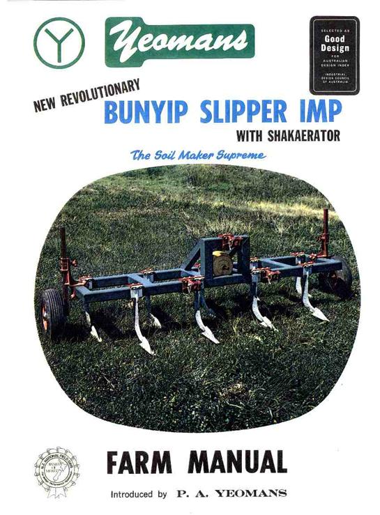
Photo 5 Bunyip Slipper Imp with Shakaerator
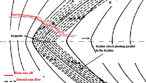
Diagram 2.
Rain and irrigation water being turned out along both ridges – adapted diagram
from P. A. Yeomans’ book ‘Water for Every Farm’ (1965, p. 60) –
used with permission
Diagram
3. Keyline Ploughing Process for Ridges - from P. A. Yeomans’ book ‘Water for Every Farm’ (Yeomans, P. A. 1965, p. 60) – used with permission.
In contrast, contour ploughing
parallel to contours other than the Keyline contour soon has water running towards
the valley’s flow line further up the valley than would naturally occur rather
than away from it towards the ridges (from a phone conversation with
Allan Yeomans Dec, 2005). Keyline ploughing is very different to contour
ploughing as described by PA Yeomans in his book ‘The Challenge of Landscape’
(1958a, Ch 6, 1958b, Chap 6).
Contour cultivation, theoretically, is
cultivation that leaves a pattern of all furrows on the true contour. However,
every run of the tractor and plough would need to follow a true contour line
marked on the land with a levelling instrument or the land must be of perfectly
even slope. Contour cultivation, as practised, is neither of these. It is
simply cultivation in the spaces between contour lines that have been
levelled-in and marked on the land by permanent or semi-permanent furrows or
banks. It leaves a pattern of furrows half parallelling up from the lower
contour and half parallelling down from the marked contour above. This pattern
is illustrated on our map-diagram (below), which is a contour map of an actual
land form, typical of country with a medium but not hard rock base. It is
granite type country.
The pattern of practical contour
cultivation is illustrated by the broken lines each representing many actual
furrows on the land. Arrow heads on the lines illustrate the downhill direction
of the furrows. Furrows without arrows may be accepted as contour lines.
It is seen from Diagram 4 that half
the lines with arrows (the top right hand set in the top diagram) fall downhill
in the general direction of the flow path
and of the valley, thereby tending to cause earlier concentration of run-off and faster flow to the valley. An approximately equal number slope
downhill in the opposite direction and away from the valley, opposing the flow lines, which at
any point are at right angles to contour lines, causing the run-off to
spread as intended with the Keyline pattern cultivation. Contour cultivation is
therefore much better than straight-line or round-the-paddock work.
Ken Yeomans in a March 2007
conversation described the fundamental difference in Keyline ploughing (refer
Yeomans (2003):
Keyline cultivation,
however, produces a pattern of furrows in which all, or a very large
majority redirect the natural flow pattern of water over land surfaces.
The result is when runoff water reaches
the flow line of a valley it forms a wider, shallower and slower flowing stream
than would otherwise occur. Only Keyline pattern cultivation has this unique
and important effect.
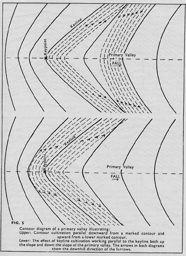
Diagram 4 from PA Yeomans (1958a, Chap 6, 1958b, Chap 6) used with
permission
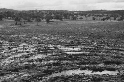
Photo 6. Plate 3 from K & PA Yeomans
book (1993) (used with permission).
Keyline pattern cultivation holds water on
a primary ridge. The source water can be from heavy rain or from the flooding
stream from a Keyline irrigation channel. In either case the water is
restrained from running off the ridge and given time to soak into the soil.
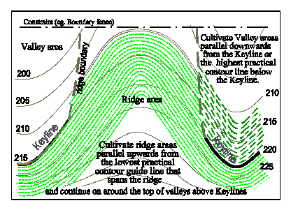
Diagram 5. Figure 12. From K
& PA Yeomans book (1993) (used with permission).
This plan emphasises the boundary between
and the pattern formed by primary valley cultivation and primary ridge
cultivation. After the cultivation is done the boundary becomes
indistinguishable.
Creating Deep Soil Fast
There is
fractal like repetition in nature (Mandelbrot 1983) and in the
Yeomans’ designs. Neville said that one of his father’s design principles was
‘work with the free energy in the system’ (Dec 1993, July 1998). This was
evident in the Yeomans use of design layout that maximized the capacity to use
gravity. Another example of thriving free energy is creating the context for
the massive increase in detritivores (worms and other organisms that break down
detritus - decaying organic matter) for generating new soil.
P.A and
Neville did not rest with the notion prevailing in most quarters, that it can
take up to 800 years to make ten centimetres of soil by rock erosion and other
breaking-down processes. They asked how they could create ten centimetres or
more of new topsoil in a few years. They reasoned that vibrant living
soil could be created by constituting an underground context/environment
bringing together detritivores with ideal combinations of air, moisture,
seasonal warmth and a steady supply of organic detritus (dead organic matter).
They
knew that cropping a certain height off grasses and plants just before
flowering/seeding either by grazing or cutting created a shock to the plant and
a comparable size of dieback in root systems. The energy that the plant had
geared up for flowering and seeding is diverted into rapid growth for survival.
The roots that die create the organic material for decomposing. What’s more,
the dead organic root matter is already spread underground through the
soil where it is needed. The space previously taken up by the roots become air
chambers. The cut vegetation material was also recycled into the soil and for a
time acts as mulch holding in any moisture present. The plant responds with
vigorous new growth that is strategically irrigated. Keyline chisel ploughing
and flood-flow irrigation would increase soil moisture content and reduce
compaction.
This
combination supplied the conditions for a massive increase in
detritivores (Yeomans, P. A.
1971b; Yeomans, P. A. 1971a; Yeomans and Murray Valley Development League 1974;
Yeomans 1976). Ten centimetres of new topsoil was
created in three years – something that was previously thought to take around 800
years! Earthworms emerged in abundance, the size of which (over 60 cm or 24
inches) had never been seen before in the region. The Riverland Journal carried
an article stating that H. Schenk, head of the Farm Bureau of America described
Nevallan earthworms as being among the best he had seen. His words were, ‘Boy
this must be the best soil ever was’ (Yeomans 1956; Yeomans, P. A. 1971b; Yeomans, P. A.
1971a). Neville told me (December 1993) he heard one
well-travelled visitor saying that the only other place he had seen comparable
worms was in the fertile fields of the Nile delta in Egypt.
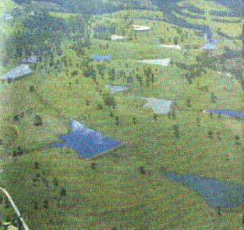
Photo 7. Chisel ‘terracing’ effect and the water harvesting achieved – Photo from P.A. Yeoman’s book ‘City
Forest Plate 1 – used with permission
In
P. A. Yeomans’ ‘City Forest’ Book (1971b;
1971a) he
acknowledges the seminal supporting role Neville played in the forming of his
ideas:
‘….as
psychiatrist and sociologist, for keeping me up to date on the social and
community implications’.
He
had Neville write the Forward (Appendix 4) to this last book (The City Forest)
about adapting his ideas to the design and layout of a city.
Thirty years after P.A.'s death, the system
he established on the farm still works by itself with little maintenance
required. As can be seen from the photo below that I took in July 2001 when I
walked the farm with Stuart Hill, the farm still looks like sweeping gardens or
a golf course. The surrounding farms were covered with dry brown grass.
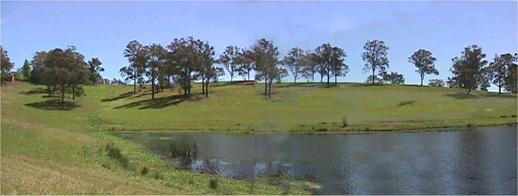
Photo 8. The farm during July
2001 looking back to the Keypoint at the left of the dam
Neville
had evolved Fraser House back in 1959 when P. A. had Keyline well under way.
Neville worked closely with his father throughout Neville’s years at Fraser
House and Fraser House outreach in the years 1968 through 1971 when the City
Forest Book was published. In the Forward to the City Forest Neville sums up
Keyline’s soil approach in these terms:
‘The
soil which gives us life must be developed in its own living processes so that
it grows richer year by year rather than poorer.’
In the 1970’s, Neville wrote a weekly
column in the Now Newspaper (a Sydney suburban paper) called ‘Yeomans Omens’ (Various Newspaper Journalists 1959-1974). In
this column he wrote that between 20,000 and 50,000 acres of Keyline forest
could totally absorb and purify the liquid effluent of Sydney. From this City
Forest clean water would re-enter the rivers and dams or the sea. A natural
by-product would be copious new fertile soil.
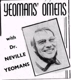
Photo 9. The
Header to Neville’s Newspaper column in the Now Newspaper
On
24 April 1974 P.A. Yeomans sent off to the South Australian Government a design
for the proposed City of Monarto in South Australia. Monarto was to be a large
metropolis to be built within the Japanese ‘Multi-Function Polis’ model[3]
for a population of 200,000. PA Yeomans based his design upon the Keyline ideas
in his book, ‘The City Forest’. A copy of these plans is in the NSW Mitchell
Library (Yeomans and Murray Valley Development League 1974). In keeping with
connexity, Yeomans’ proposal linked into all the aspects of the local context
into his the design including reckoning land-scale factors, as well as
geological structure and other features including: shape, form, climate,
natural plant cover, various soil types, capacities for development and use for
the city, climate factors - prevailing wind, pattern of temperature, annual
rainfall, amount and incidence of runoff, including all water that flows from
outside and across the cityscape, waste water, and water runoff from roads,
roofs, and sealed surfaces. Yeomans’ proposal incorporated the use of city
effluent for irrigation of forests to be planted in the proposed city, and the
purification of the surplus water by passing it through the forest soil and
biosystem.
The
Monarto plan mentions that:
‘Many
species of trees that grow in medium rainfall areas respond to the greatly increased
water and fertilizing factors of the effluents by producing several times their
normal timber and with improved cell and fibre structure.
For
instance, trees for fence posts are available three years after planting.
By
that time rainforest soil will have been created more than 150cm (5 feet)
deep (my italics) (Yeomans and Murray Valley Development League 1974).
Many other people and groups sent in design
proposals. There was a large amount of conjecture about and resistance to the
concept of Multi-Function Polis and the city of Monarto was never built.
Designing Farms
A
fundamental aspect of Keyline is that it involves design, and not just any
design; rather, a design guided by nature in the local place and context, such
that the resultant design superbly fits the local natural system. The Yeomans
let nature tell them what to do. They always attended to nature and respected
the design in nature, and designed and redesigned their interventions in a way
that melded in with nature’s design, ‘design principles’ and emergent
properties (Capra 1997, p.28). The
Yeomans used ‘dynamic living systems’ as a strategic frame in their thinking,
design work and action. They also used bio-mimicry (mimicking nature) in their
designs (Suzuki and
Dressel 2002, p. 66, 110). They engaged
with all of the inherent aspects of the farm as a holarchical living system (Holonic
Manufacturing Systems 2000). They were ever
aware that the ‘wholes’ in the living systems of the farms were made up of
parts, and these parts were themselves wholes made up of parts. The Yeomans
were very connected to this web of linkages.
After
the Yeomans had introduced some changes to the soil environment the massive
changes were self-organizing. The soil, organic matter, water and
detritivores, as naturally occurring integrated systems, had emergent
qualities; that is, aspects started emerging, or coming into being, which had
not being present at lower levels of organization.
In December 2005, Allan Yeomans told me
that the special properties and significance of Keypoints and Keylines, as well
as the associated design principles such as Keyline cultivation, and placement
of roads, fences and irrigation channels were slowly realised over a number of
years. Keyline insights and design principles guide placement of paddocks, rows
of trees as windbreaks and shade for stock, fences, gates, and roads. Landform
and flood irrigation flow are also taken into account in designing where
paddock boundaries are placed. The photo below shows the strategic design of
tree plantings as windbreaks and shade for livestock.
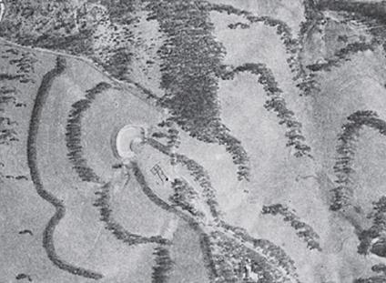
Photo 10. Aerial photo of the Trees on Nevallan
- Photo from Priority One – Together We can Beat Global Warming (Yeomans,
A. 2005, p. 137) –
Used with permission
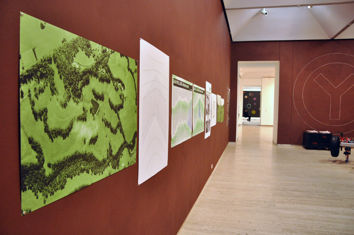
Jan 2014 Yeomans
Project – Art Gallery of NSW
Before P. A. and his sons’
work, Australian (and other) farms had rarely been designed. They tended to evolve in a
haphazard or ‘traditional’ way – ‘this is the way we always do it’. Farmers
would impose their will on nature (‘dominion over’ in the Jewish and Christian
tradition). If something was ‘in the way’, farmers would ‘bulldoze’ it out of
the way.
In designing and using Keyline, things are
placed relative to other system parts and place for maximizing working well
with nature, functionality, emergence, inter-related fit, and use of free
energy in the system (for example, using gravity, and the transformative energy
of the detritivores that
break down organic matter). Neville spoke to me (Dec 1993) of his father
constantly fine-tuning things till they would fit. Neville described this as
‘the survival of the fitting’. This is discussed more fully in other places (Yeomans 1954; Yeomans, Percival. A. 1955; Yeomans
1958b; Yeomans 1958a; Holmes 1960; Yeomans, P. A. 1965; Yeomans, P. A. 1971b;
Yeomans, P. A. 1971a; Yeomans 1976; Yeomans and Yeomans 1993; Hill 2000;
Holmgren 2001; Yeomans 2001; The Development Of Narrow Tyned Plows 2002).
Neville’s father made repeated use of ‘do
the opposite’ type lateral thinking. For example, P.A. experimented with
putting a pipe through dam walls – something conventional wisdom said was never done because of ‘inevitable’ wash
out along the outside of the pipe. Neville’s father solved this problem by
putting baffles along the outside of the pipe. Water running along the outside
would carry with it small gravel and soil particles that would be trapped by
the baffles and fill in any gaps and compact the soil around the outside of the
pipe and therefore strengthen the seal around it. Because dams were placed high
in the land topography, all the Yeomans had to do was turn on the valve on the
outside base of each dam wall on their properties and they had gravity fed
flowing water. No pumps and associated power were required.
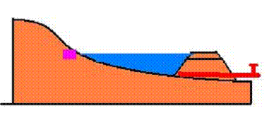
Diagram 6. Pipe through dam wall with the dam filled
to the Keypoint
marked by the square
Given that Australia is the driest inhabited continent and
the wide spread concern about the extensive and prolonged drought in Australia,
and concerns about water storage, allocation and use, and the capture and use
of storm water and grey water in urban areas, as well as the social relocation
of farmers to open up new farming areas the Australia’s far North, it is timely
to revisit PA Yeoman’s work especially within a context of Dr Neville Yeomans
application of his father’s ideas in re-constituting society.
Ideas are evolving for applying the Keyline wisdom above in
increasing the fertility and volume of soil on Pacific Islands as a world model
towards fertile futures.
Another perspective on the Yeomans - for thousands of years
people have recognised primary valleys. They all rise to a main ridge flanked
by primary ridges. Something about the Yeomans enabled them to see the
significance of the Keypoint and Keyline. No one else in human history, as far
as can be found, has ever seen that
significance before. This raises the question:
what was it that enabled the Yeomans to spot the
significance
PA Yeomans wrote in his book, The Challenge of Landscape: The Development and Practice of Keyline.
(1958):
Once the eye becomes trained to see these simple land
shapes, and the mind has selected and classified one or two, there is a
fascination in the continuous broadening of one’s understanding and
appreciation of the landscape (1958, p. 56).
Even this does not get it. One buys a VW Beetle and one
suddenly notices other VW Beetles all over the place.
What enabled the Yeomans to spot the significance of the
Keypoint and Keyline in the first place? This perhaps is the deep significance
of the Yeomans family’s life work.
This thread is explored through Laceweb pages.
Other Links:
An Australian Pioneer - The Life Work
of Dr. Neville Yeomans