Chapter Five - Connecting
Sustainable Agriculture
and Psychosocial Transition
ORIENTING
This
Chapter explores the research question, ‘What were the theoretical and action
precursors firstly, to Neville Yeomans evolving the therapeutic community
psychiatric unit Fraser House, and secondly, to the ways of being and acting
that Neville Yeomans used in his life work?’
Some aspects of Neville Yeomans’ way of
thinking, processing and acting are detailed, and their origins are firstly
traced to the innovative work that Neville did with his father Percival A.
Yeomans and brother Allan (and later with the younger brother Ken) in evolving
Keyline, a set of processes and practices for harvesting water and creating
sustainable agriculture. The chapter then details the influence on the Yeomans
of Australasia Oceania and East Asia Indigenous and grassroots ways.
INSPIRING TRAUMA
Neville’s
two traumatic incidents mentioned in Chapter One also had a profound, though
different impact on P.A. Yeomans, his father (Mulligan and Hill
2001, p. 193).
Neville’s father was, at the time Neville was lost, a mine assayer and a keen
observer of landscapes and landforms. His
father was
deeply impressed by the Aboriginal tracker’s profound knowledge of the minutiae
of his local land, such that, in that harsh dry rocky climate with compacted
soils, he could so readily follow the minute traces left as evidence of the
movements of a little boy. The other thing was that upon finding little
Neville, the tracker was so intimately connected to the local land and its
form, he knew exactly where to go to find water. It was not that this tracker
knew where a creek or a water hole was, as there was no surface water. He knew
how to find water whenever he wanted it, and wherever he was in his homeland.
He and his people ‘be long’ there (40,000 plus years). They were an
integral part of the land. They were never apart from it. The tracker and his
community saw the Earth as a loving Mother that provided well for them
continually (‘The Earth Loves us’ – from Neville’s Inma poem). The tracker was
‘of the land’. As soon as the tracker found Neville, he had to find the
right kind of spot for a short easy dig. Because of Neville’s dehydration, the
tracker needed water for Neville fast. He used his knowledge of his place and
quickly had Neville sipping water.
Mulligan
and Hill report that:
According
to Neville, it was probably this incident that gave his father his enduring
interest in the movement of water through Australian landscapes, because he
could see that an understanding of this would be a huge advantage for people
living in the driest inhabited continent on Earth (2001, p. 193).
In
the years after leaving mine assaying, P.A. Yeomans had moved on to having his
own earth-moving company. P. A. had just purchased the Nevallan and Yobarnie
properties in
WATER TELLING US WHAT TO DO WITH IT
P.
A. emulated the Aboriginal tracker in becoming familiar with the landform of
his two properties. P.A. wanted to store or use all of the water that landed
on the properties. In the Forties, P.A. wanted to be able to water his two
properties so they were so lush and green all year round, they would be
virtually fireproof. When the families acquired the properties the soil was
‘low grade’. It was undulating hill country with plenty of ridges that were
composed of low-fertility shale strewn with stones. The following photo taken
at Nevallan, one of the Yeomans’ farms, shows the original poor shale and rock
‘soil’ throughout the two properties when the properties were acquired.
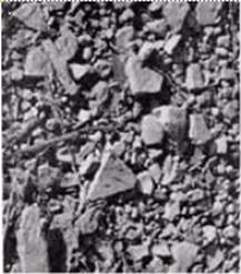
Photo 1The low fertility shale
strewn with stones on P.A’s farm - from Plate 30 in
P.A.’s book ‘Challenge of Landscape’ – used with permission (Yeomans 1958b; Yeomans 1958a)
Photo 11 shows a
spade full of fertile soil after two years of the processes evolved by P.A. and
his sons. To clearly show the difference in the soil, a clump of the fertile
soil has been placed beside earth on the base of a tree stump that became
exposed when the tree fell over. This lighter low-grade soil had not been
involved in the processes the Yeoman’s evolved.
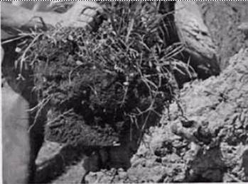
Photo 2 Fertile soil after two years compared to the original soil - a copy of Plate 30 in P.A.’s book
‘Challenge of Landscape’ - Used with permission
Within
three years, Yeomans and his sons had energized what conventional wisdom said
was impossible; they had altered the natural system so that the natural
emergent properties of the farm, as ‘living system’, created ten centimetres (4
inches) of lush dark fertile soil over most of the property. What is important
is that the local natural ecosystem did the work. P.A. enabled emergent aspects
in nature to self-organize towards increased fertility. With the interventions
that P.A. introduced, the property became lush and green twelve months of the
year. It was virtually fireproofed!
In 1974,
P. A described processes whereby 4 inches (10.16 cms) of deep fertile soil
could be created within three years (Yeomans
and Murray Valley Development League 1974).
The
balance of this chapter will specify the processes the Yeomans evolved and
applied on their farms and the Indigenous precursors they drew upon. It then
briefly introduces the ways Neville evolved in adapting his family’s farming
processes to psychosocial change.
Keyline
Emerges
Over
thousands of years, if this continent’s Aborigines wanted to spear fish in the shallow
creeks and rivers, they would copy the behaviour of the wading birds that wade
slowly, and then react extremely fast with their long beaks. The Aboriginal
hunter with his spear mimics these waders. Resonant with the continent’s
Indigenous ways, P.A. and his sons engaged in bio-mimicry - letting the water,
the landforms, the soil biota, and the balance of the local eco-system tell
them what to do. Neville told me (July 1998) that P.A. would take Neville and
Neville’s younger brother Allen out onto the farms as they were growing up
whenever it rained so they all could learn to see directly how the rain soaked
in at different times, how long before run-off would occur on different land
forms, and what paths down the slopes the run-off moved on different land
shapes. Like the Aborigines, they were learning to have all of their senses
focused in the here-and-now, attending to all that was happening in nature. As
action researchers, they became connoisseurs of their land and all life on it (Eisner 1991, p. 176). Whatever action P.A. and his sons did, they
always observed how nature responded.
P. A.
obtained contour line maps with a useful scale of his property to further aid
his understanding of landform. According to Ken Yeomans in an October 2003
phone discussion, the map scale was typically 1 in 25,000 with 5 metre contours. Neville
said that his father constantly referred to the three primary landscape features - the
main ridge (elevated from the horizontal), the primary ridge (lateral to the
main ridge) and the primary valleys (lateral vertical cleavages). The farm was
perceived by P.A. as a cleavered unity, a feature pervasive in nature. P. A.
discovered where the best places were to store run-off water for maximum later
distribution using the free energy of gravity feed. It was high in a special
place in the primary valleys. Overflow from dams high in the primary valleys
were linked by gravity-based over-flow channels to lower dams.
Below is the most succinct statement I have
found written by P.A. Yeomans about what he called ‘Keyline’. I have extracted
it from P.A.’s speech at the UN Habitat ‘On Human Settlements’ Forum in
Keyline relates to a special feature of
topography namely, the break of slope that occurs in any primary valley.
Primary valleys are the highest series of valleys in every water catchment
region and lie on either side of a main or water divide ridge. They are widely
observed as the generally smooth or grassed over valleys of farming and grazing
land but are often overlooked and disguised in the city. On either side of the
primary valley is a primary ridge. Of the three basic shapes of land, namely,
main ridge, primary valley and primary ridge, the primary valley shape occupies
the smallest area of land and the primary ridge shape, the largest. In the
rural situation irrigation is a matter of watering the large primary ridge
shapes, even on land which appears flat.
All of the structures, processes and
practices that P. A. Yeomans evolved he also called Keyline (Yeomans, P. A. 1971b; Yeomans, P. A. 1971a). Diagram 1
shows the main ridge (the dotted line along the left), two primary ridges (with
the arrows) and two primary valleys.
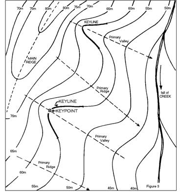
Diagram 1 – Photo from P.A.’s UN Habitat Speech (1976, p. 9)
Note that the Keypoint is on the fall line
on the contour above the first wider gap between the contours. The fall line is
marked on Diagram 1 above as the dotted line through the Keypoint. This wider
space between contours indicates less steepness on the slope.
Above the Keypoint is typically an
armchair-shaped land form that directs the water run-off so that most of it
ends up arriving in an area that may be as small as a square metre (the Keypoint)
– sometimes the very start of the typical creek as creek.
P.A. found that the optimal locations for
dams along the Keyline are where it crosses the drainage lines within primary valleys.
As stated, he called these the Keypoint for that primary valley.
P.A.’s
‘On Human Settlements’ Forum speech contains another description of Keyline:
It
will be observed that in the primary valleys the first slope falling from the
ridge above is short and steep – usually the steepest slope in the immediate
environs – while the second slope is flatter, much longer and extends to the
watercourse below. The point at which the change occurs between these two
slopes is named the Keypoint; the Keyline extends on the same level on either
side of this Keypoint and partly encloses a concave shape on the land. Only
primary valleys have Keylines (see contour diagram above) (Yeomans, P. A.
1971b; Yeomans, P. A. 1971a; 1976, p. 7-8).
Ken
Yeomans in a December 2005 email referred to the above quote:
I question the technical
accuracy of saying it ‘partially’ encloses a concave shape on the land.
Actually the Keyline occupies all of the concave shape of the contour line
curve. The change of direction of the contour from concave through the valley to the
convex curve of the ridge defines the end of the Keyline on
either side of each primary valley.
Diagram 1 above shows Ken Yeomans point
mentioned above - that the Keyline extends either side of the Keypoint for a
particular distance along the contour line running through the Keypoint.
P.A
then goes on to give a key point summary (1976, p. 9):
The
Keyline is significant because:
1. It is the first place in any valley where
rain run-off water, concentrated from the higher slopes, can form a stream.
2. It is also the first place where run-off
water disappears when the rain stops unless the water is contained.
3. It is the highest possible storage site in
any valley of the land.
4. It is often the highest point at which good
construction material for earth dams is available (higher up the earth may be less
decomposed and less suitable for dam building).
5. It is the essential starting point for a
water control system in any landscape that produces run-off; and
6. It is the line of change when the three
shapes of the land merge and readily disclose the geometry of land contours and
the behaviour of surface flowing waters.
The
Keyline is thus of major significance to any concept that aims to enrich the
environment by controlling and using all available water.
Note
point six above - the Keypoint in nature is saturated with information carrying
capacity. On this typically square metre of land is the junction of all three
land forms. Information distributed through each landform is present at the
Keypoint. The Keypoint, for those with eyes to see, is the place that reveals
the interaction of water with land. There is a confluence at the Keypoint of
all the water runoff from the main ridge and adjacent primary ridges down the
curved slope at the head of the primary valley.
Lincoln
and Guba made a similar point about distribution of information within a system
(quoted in Chapter Four):
Information
is distributed throughout the system rather than concentrated at specific
points. At each point information about the whole is contained in the part. Not
only can the entire reality be found in the part, but also the part can be
found in the whole. What is detected in any part must also characterize the
whole. Everything is interconnected (1985, p. 59).
The
Yeomans’ genius was that they spotted the information distributed throughout
the three landform systems and saw how the distributed information inter-connects
and interacts at the Keypoint. Keypoints are saturated with information that is
distributed in the system. Sensing and observing the Keypoint may reveal
insights as to how the whole complex dynamic system works.
Resonant with the above, Neuman also makes the observation that at
each point in a living system, information about
the whole is contained in the part (1997, p. 433).
Not only can the entire reality be found in the part, but also the part can be
found in the whole. What is detected in any part must also characterize the
whole. Everything is interconnected, inter-dependent, inter-related and
inter-woven.
Also
resonant with Yeomans and Neuman, Joseph Jaworski (1998, p. 80)
writes of a conversation with theoretical physicist Dr. David Bohm:
We
were talking about a radical, disorientating new view of reality which we
couldn’t ignore. We were talking about the awareness of the essential
inter-relatedness of all phenomena – physiological, social, and cultural. We
were talking about a systems view of life and a systems view of the universe.
Nothing could be understood in isolation, everything had to be seen as a part
of the unified whole.
Jaworski
writes of Bohm saying that it’s an abstraction to talk of nonliving matter:
Different
people are not separate, they are all enfolded into the whole, and they are all
a manifestation of the whole. It is only through an abstraction that they look
separate. Everything is included in everything else.
Yourself
is actually the whole of mankind. That’s the idea of implicate order – that
everything is enfolded in everything.
While
Jaworski and Bohm were talking about a ‘radical, disorientating new view of
reality’, this view has been the natural view of Australian Aborigines since
antiquity, and it was this view that the Yeoman’s used to perceive
inter-related things that Western farmers had never seen before. Barabasi (2003)
in his book ‘Linked - How Everything is Linked to Everything and What it Means’
also explores the same theme. Consistent with the foregoing, for the
Yeomans, the farm was a living system made up of interconnected, inter-related,
inter-dependent and interwoven living systems and associated inorganics. I have
been referring to this as ‘connexity’; this term was not used by Neville or the
other Yeomans, although it connotes their understanding of system linkages
well.
Where
the context around a Keypoint made it possible P.A. placed a dam wall so that
the dam could fill to that Keypoint. He designed his farms Nevallan and
Yobarnie to fit nature. All of the dams were placed so as to simultaneously get
water run-off, pass overflow to a dam below by gravity, and by gravity-based
irrigation, pass on the water to the soil when desired. Neville (August 1998)
and Allan (May 2002) both confirmed that they were with their father at the
moment when they recognized what he called the Keypoint and the Keyline in
landform – the central concepts in Keyline (Yeomans 1955a, p. 118). The very
spot where they realised the significance of the Keypoint is where the closest
water is in the closest dam in photo 12 below; the primary
ridges are on the left and right of the primary valley.
P.A.
wrote:
Once
the eye becomes trained to see these simple land shapes, and the mind has
selected and classified one or two, there is a fascination in the continuous
broadening of one’s understanding and appreciation of the landscape (1958, p.
56)
In
December 2005 Allan Yeomans told me that the special properties and
significance of Keypoints and Keylines as well as the associated design
principles such pattern cultivation, and placement of roads, fences and irrigation
channels were slowly realised over a number of years. Photo 14 below shows
strategic design of tree plantings as windbreaks and shade for livestock.
The Social Ecologist, Stuart
Hill and I visited Nevallan for the first time in 2001 and I took photo 15 below showing the place where P.A. and
Neville first spotted the Keypoint and Keyline. Like all Keypoints, the one in
the photo is on the drainage line. Photo 15
shows one of the primary ridges on the left near the top of the primary valley.
Photo 3 in Chapter One was taken looking up towards
where photo 15 taken.
Stuart
Hill, in Chapter Eight of his book on Australia’s Ecological Pioneers, outlines
some aspects of the process P. A. and his sons used (Mulligan and Hill
2001, p. 193):
What Yeomans senior discovered through
such patient observation was that there is a line across the slope of a
hillside where the water table is closest to the surface. The ground along this
line looks wettest and is reflective when it rains heavily.
Photo 3(Yeomans, A. 2005, p. 137) – Used with permission
Photo 4 down towards the Keypoint at the top of the dam.
It is the line along which it makes most
sense to locate the highest irrigation dams within the landscape, because this is
where the run-off water from above can most effectively be collected and
subsequently used at the most appropriate time to irrigate the more gently
sloping land below. Yeomans called this line the Keyline.
Yeomans first outlined his ideas about water
movement and how to detect Keypoints in a book entitled, ‘The Keyline Plan’ (1954). The books, ‘Challenge of Landscape’ (Yeomans 1958a), ‘Water for Every Farm’ (Yeomans, P. A. 1965), and ‘The City Forest’ (Yeomans, P. A. 1971a) followed. Three of P.A.
Yeomans’ books, ‘The Challenge of Landscape’ (Yeomans 1958b), ‘The Keyline Plan’ (Yeomans, P. A. 1955), and the ‘City Forest
: The Keyline Plan for the Human Environment Revolution’ (Yeomans, P. A. 1971b), including all of
their diagrams and photos, are now on-line on the Internet through the Soil and
Health Organization.
In
1993, Ken Yeomans, Neville’s younger brother published his book, ‘Water for
Every Farm: Yeoman’s Keyline Plant’ (Yeomans
and Yeomans 1993). This book clarified
some aspects of Keyline.
Alan Yeomans in a phone conversation
(December 2005) noted that the Keypoint and Keyline in successive primary
valleys along a ridge have an ascending (or descending) elevation as occurs in
Diagram 1 above. Allan spoke of regular patterns in nature; as an example, the Yeomans’
experience was that often the height of the bottom of a dam wall below a
keypoint in a primary valley been the height of the top of the dam wall in the
next lower primary valley (refer Diagram 1 above). This has implications for
linking the two dams by over-flow channel along a contour.
A
key aspect of Keyline was how the Yeomans changed the interaction between water
and soil. P. A. used chisel ploughing parallel to the Keyline, allowing the
natural self-organizing flow of water to run into these chiselled grooves. This
is not the same as contour ploughing as ploughing parallel to the Keyline soon
goes ‘off contour’ in a gentle downhill direction with an important effect.
This chisel ploughing results in shifting the direction of flow of surface water
around 85 degrees to flow down hill more slowly along the sides of the primary
ridges on each side of the primary valley. In contrast, contour ploughing has
the reverse effect, namely directing water towards the bottom of the primary
valley (from a phone conversation with Alan Yeomans Dec, 2005). Keyline
ploughing stops an eroding rush of surface water down to the valley floor,
slows the flow, spreads the soaking, and allows for a massive increase in the
moisture levels in the soil without water-logging. Consequently, water is
‘stored’ as it slowly filters through the soil, as well as being kept in all
the dams. The chisel plough that the Yeoman’s developed was called the Bunyip
Slipper Imp with Shakaerator (that is it shakes and aerates). This shaking action
reduces soil compaction. P. A. Yeomans won the Prince
Phillip Agricultural Design Award in 1974 for his design of this plough shown
in photo 16.
The
plough has the effect of placing a loose cap on a chisel groove so there is air
and space for water run-off to run along in the grooves underground. This cap
on the top of the groove minimises evaporation by sun and wind (Foster
2003). These changes to
the soil and water interaction are vital in the driest inhabited country in the
World. P. A. did not use ploughing that inverted the soil as he found that it
damaged soil ecology.
In
Diagram 2below, the red lines depict rainwater
run-off as it happens without the chisel ploughing. Once the run-off hits the
chisel ploughing it is turned around (approximately) 85% and runs out along the
ridges on both sides of the valley.
On the ridges, chisel
ploughing is carried out parallel to a selected contour line as depicted in
Diagram 4. Notice that the fall-line and the chisel grooves
are again at around 85 degrees to each other. This ploughing pattern on the
ridges also turns the rain or irrigation water flowing on the ridges from
running straight off the sides of the ridge. The chisel cuts have the water
again turned so that it runs at a much shallower slope along the side of
the ridge. This again slows the speed of run-off and allows the water to be
stored as it passes through the soil.
Creating Deep Soil Fast
There is fractal like repetition in nature
(Mandelbrot 1983) and in the Yeomans’ designs. Neville said that one of his
father’s design principles was ‘work with the free energy in the system’ (Dec
1993, July 1998). This was evident in the Yeomans use of gravity and the design
layout that maximized the capacity to use gravity. Another example of thriving
free energy is creating the context for the massive increase in detritivores
(worms and other organisms that break down detritus - decaying organic matter)
for generating new soil (discussed later).
P.A and Neville did not rest with the
notion prevailing in most quarters, that it can take up to 800 years to make
ten centimetres of soil by rock erosion and other breaking-down processes. They
asked how they could create ten centimetres or more of new topsoil in a few
years. They reasoned that soil could be created by constituting an
underground context/environment bringing together detritivores with ideal
combinations of air, moisture, seasonal warmth and a steady supply of organic
detritus (dead organic matter).
They knew that cropping a certain height
off grasses and plants just before flowering/seeding either by grazing or cutting
created a shock to the plant and a comparable size of dieback in root systems.
The energy that the plant had geared up for flowering and seeding is diverted
into rapid growth for survival. The roots that die create the organic material
for decomposing. What’s more, the dead organic root matter is already
spread underground through the soil where it is needed. The space previously
taken up by the roots become air chambers. The cut vegetation material was also
recycled into the soil. The plant responds with vigorous new growth that is
strategically irrigated. Keyline chisel ploughing and flood-flow irrigation
would increase soil moisture content and reduce compaction. This combination
supplied the conditions for a massive increase in detritivores (Yeomans, P. A. 1971b; Yeomans, P. A.
1971a; Yeomans and Murray Valley Development League 1974; Yeomans 1976).
Ten
centimetres of new topsoil was created in three years – something that
was previously thought to take around 800 years! Earthworms emerged in
abundance, the size of which (over 60 cm or 24 inches) had never been seen
before in the region. The Riverland Journal carried an article stating that H.
Schenk, head of the Farm Bureau of America described Nevallan earthworms as
being among the best he had seen. His words were, ‘Boy this must be the best
soil ever was’ (Yeomans
1956; Yeomans, P. A. 1971b; Yeomans, P. A. 1971a). Neville told me
(December 1993) he heard one well-travelled visitor saying that the only other
place he had seen comparable worms was in the fertile fields of the Nile delta
in
Thirty
years after P.A.'s death, the system he established on the farm still works by itself
with little maintenance required. As can be seen from Photo
18 below that I took in July 2001 when I walked the farm with Stuart
Hill, the farm still looks like sweeping gardens or a golf course. The
surrounding farms were covered with dry brown grass.
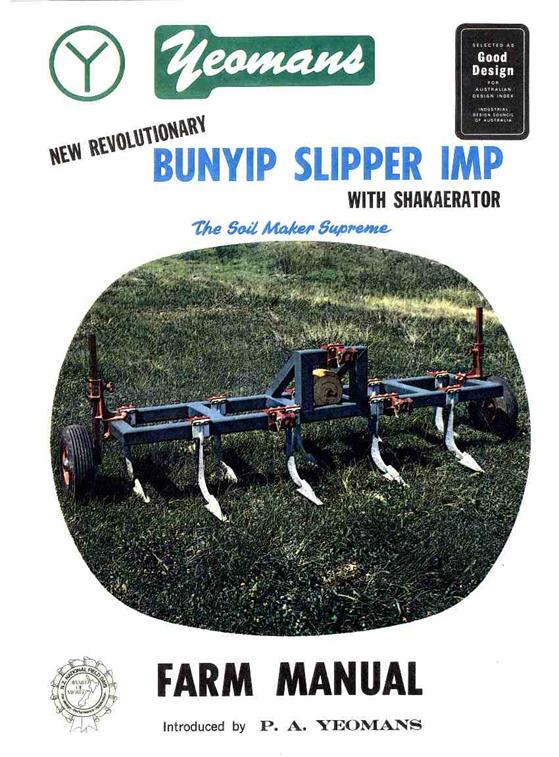
Photo 5

Photo 6 effect and the water harvesting achieved – Photo from P.A. Yeoman’s
book ‘City Forest Plate 1 – used with permission
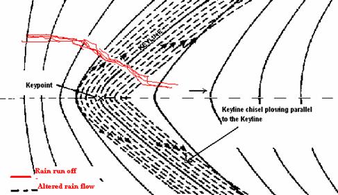
Diagram 2 – adapted diagram from P. A. Yeomans’ book
‘Water for Every Farm’ (1965, p.
60) – used with permission
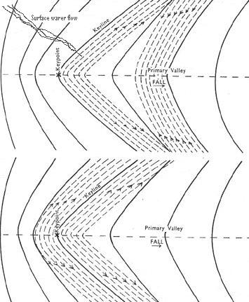
Diagram
3 Rain and irrigation water being turned towards or away from ridges – adapted diagram from P. A. Yeomans’ book ‘Challenge
of Landscape (1958b,
Chap 6, Fig. 5) – used with permission
In
Diagram 3 note that the contour lines above the Keyline are closer to each
other in the middle of the valley and get wider apart as they go towards the
primary ridges. Below the Keyline is the reverse pattern. The contour lines are
wider apart in the middle of the valley and get closer towards the primary
ridges. This difference in form gives the Keyline a property that no other
contour line has. Note that in the upper section of Diagram 3 contour
cultivation is parallel downward from a Keyline contour and the furrows track
water (the direction of surface water flow is depicted in top left of diagram
3) out towards the ridges. Note also that the second set of furrows upward from
a lower marked contour results in water flowing towards the centre of
the valley and that this would create the potential of erosion. Any ploughing
parallel to any contour above or below the Keyline in the valley has the
effect of tracking water towards the bottom of the valley rather than out
towards the ridges. The lower segment of
Diagram 3 shows the effect of Keyline cultivation working parallel to the
Keyline both up the slope and down the slope of the primary
valley. All of these furrows track water out along the ridges aiding the
slow passage of water through the farm. The arrows in both diagrams show the
downhill direction of the furrows.

Diagram 4 Keyline Ploughing Process
for Ridges - from P. A. Yeomans’ book
‘Water for Every Farm’ (Yeomans, P. A. 1965, p. 60) – used with permission.
In his 1971 ‘City Forest’ Book P. A.
acknowledges the seminal supporting role Neville played in the forming of his
ideas, ‘as psychiatrist and sociologist, for keeping me up to date on the
social and community implications’. He had Neville write the forward (Appendix
4) to this last book – The City Forest – about adapting his ideas to the design
and layout of a city (Yeomans, P. A. 1971b; Yeomans, P. A. 1971a).
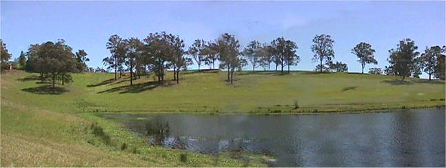
Photo 7 at the left of the dam
Neville had evolved Fraser House back in 1959
when P. A. had Keyline well under way. Neville worked closely with his father
throughout Neville’s years at Fraser House and Fraser House outreach in the
years 1968 through 1971 when the City Forest Book was published. In the Forward
to the City Forest Neville sums up Keyline’s soil approach in these terms:
‘The soil which gives us life must be
developed in its own living processes so that it grows richer year by year
rather than poorer.’
In the
1970’s, Neville wrote a weekly column in the Now Newspaper (a Sydney suburban
paper) called ‘Yeomans Omens’ (Various
Newspaper Journalists 1959-1974). In this column he wrote that between 20,000
and 50,000 acres of Keyline forest could totally absorb and purify the liquid
effluent of
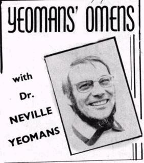
Photo 8The Header to Neville’s
Newspaper column in the Now Newspaper
The
Yeomans let nature tell them what to do. They always attended to nature and
respected the design in nature, and designed and redesigned their interventions
in a way that melded in with nature’s design, ‘design principles’ and emergent
properties (Capra 1997, p.28). The
Yeomans used ‘dynamic living systems’ as a strategic frame in their thinking,
design work and action. They also used bio-mimicry (mimicking nature) (Suzuki
and Dressel 2002, p. 66, 110) in their
designs. They engaged with all of the inherent aspects of the farm as a
holarchical living system (Holonic
Manufacturing Systems 2000). They
were ever aware that the ‘wholes’ in the living systems of the farms were made
up of parts, and these parts were themselves wholes made up of parts. The
Yeomans were very connected to this web of linkages.
After the Yeomans had introduced some changes to the soil
environment the massive changes were self-organizing. The soil, organic
matter, water and detritivores, as naturally occurring integrated systems, had
emergent qualities; that is, aspects started emerging, or coming into being,
which had not being present at lower levels of organization.
Designing
Farms
A
fundamental aspect of Keyline is that it involves design, and not just any
design; rather, a design guided by nature in the local place and context, such
that the resultant design superbly fits the local natural system.
Keyline insights and design principles guide
placement of paddocks, rows of trees as windbreaks and shade for stock (see
Photo 14), fences, gates, and roads. Landform and flood irrigation flow are
also taken into account in designing where paddock boundaries are placed.
Before P. A. and his
sons’ work, Australian (and other) farms had rarely been designed. They
tended to evolve in a haphazard or ‘traditional’ way – ‘this is the way we
always do it’. Farmers would impose their will on nature (‘dominion over’ in
the Jewish and Christian tradition). If something was ‘in the way’, farmers
would ‘bulldoze’ it out of the way.
In designing and using Keyline, things are
placed relative to other system parts and place for maximizing working well
with nature, functionality, emergence, inter-related fit, and use of free
energy in the system (for example, using gravity and the transformative energy
of the detritivores that break down organic matter). Neville
spoke to me (Dec 1993) of his father constantly fine-tuning things till they
would fit. Neville described this as ‘the survival of the fitting’. This is
discussed more fully in other places (Yeomans 1954; Yeomans, Percival. A. 1955;
Yeomans 1958b; Yeomans 1958a; Holmes 1960; Yeomans, P. A. 1965; Yeomans, P. A.
1971b; Yeomans, P. A. 1971a; Yeomans 1976; Yeomans and Yeomans 1993; Hill 2000;
Holmgren 2001; Yeomans 2001; The Development Of Narrow Tyned Plows 2002).
Neville’s
father made repeated use of ‘do the opposite’ type lateral thinking. For
example, P.A. experimented with putting a pipe through dam walls – something
conventional wisdom said was never done because of ‘inevitable’ wash out along
the outside of the pipe.
Neville’s
father solved this problem by putting baffles along the outside of the pipe.
Water running along the outside would carry with it small gravel and soil
particles that would be trapped by the baffles and fill in any gaps and compact
the soil around the outside of the pipe and therefore strengthen the seal
around it. All the Yeomans had to do was turn on the valve on the outside base
of the dam wall and they had gravity fed flowing water.

Diagram 5
marked by the square
So
far in this chapter we have summarised the Yeomans family’s evolving of Keyline
and discussed aspects of their farm designing and the way they worked with
nature to foster the self-organizing emergence of abundant fertility. The next
section explores some of the Indigenous origins of the Yeomans’ ways.
LINKS BETWEEN
SUSTAINABLE AGRICULTURE, PSYCHOSOCIAL CHANGE AND INDIGENOUS SOCIOMEDICINE
Indigenous influences on the Yeomans’ ways
will now be considered. Through P.A.’s
work in remote areas across the Top End of Australia and
For
Indigenous people living as nomadic hunter-gatherers on this continent, social
cohesion is a central component of healing and vice versa. The concept of
Indigenous ‘sociomedicine’ is implicit in psychiatrist Cawte's book, ‘Medicine
is the Law’ and other writings (Cawte
1974; 2001).
Neville
spoke (Dec 1993) about Aboriginal and Torres Strait Islander people living
traditional lives – for them, bush remedies for a wide range of troubles are
both widely known and widely used. This was confirmed by Geoff Guest (Aug
2004). However, if in these contexts sickness is deemed to have its source in social
trouble - if social cohesion is under threat - sociomedicine is used by
only a few law people who know the ways.
Neville understood the pervasive way
Aboriginal sociomedicine is linked into social cohesion.
The focus for healing or prevention is the whole group, and all become
involved (Cawte
1974; Cawte 2001).
Neville had firsthand experience of Aboriginal and Torres Strait Islander
artistry - stories, sand drawings, rock paintings, songs and dances - and how
all are used to maintain social cohesion in being well together in community. Neville evolved his social action on his
understanding that for Aboriginal and Torres Strait Islander people, social
cohesion among one's people is paramount and isomorphic with the cooperative
inter-relationships found in nature.
Neville
and his father had been linked into these ways of thinking and experiencing
each other and the World. Through his life Neville had been accepted into
Yolgnu Aboriginal Communities living traditional lives in their homelands in
Arnhemland in the Australia Top End. Neville told me (July 1994), he had
experienced the storytelling and the singing and the corroborees. He had gone
hunting with them and participated in ancient ceremonies associated with a
person’s death, as well as other ceremonies. Neville said that these psycho-physical
and metaphysical experiences profoundly linked him into extremely rich
antiquities. Neville described these experiences as equalling any of the wisdom
literatures he had read, and certainly having the richness of the mythologies
of Grecian, Indian, Mayan and other cultures.
It is very easy to get lost in
the
Indigenous people constantly ‘absorb’ their land through all of
their senses. Being in their land has emotional tone; the land is in them and
they are in it, and of it. Neville acted from deep within this rich sensuous
emotional consciousness of connexity to and with land.
Neville
spoke of all manner of artistic expression and borrowing from nature being used
by Indigenous people of the Australasia Oceania Region to sustain and enhance
the social cohesion in their way of life. This artistic expression and social
action is called by some Indigenous people in the Region, especially those in
Vanuatu, ‘cultural action’, a term now being used throughout the Oceania
Australasia East Asia Region (CIDA 2002; Queensland Community Arts
Network 2002). Neville adapted this ‘cultural action’
into ‘cultural healing action’ (Yeomans and Spencer 1993). Neville described (December, 1993)
Cultural Healing Action to me as combining and embracing
the healing artistry of music making, percussion, singing, chanting, dancing,
reading poetry, storytelling, artistry, sculpting, puppetry, model making and
the like - and using any and all of these for increasing wellbeing. Neville was adept at using and enabling
Cultural Healing Action and he enabled me to gain competences in using it as
well.
Before,
during and after Fraser House, Neville had an increasing realization of the
resonance between Keyline, Cultural Keyline and Indigenous Self-Earth Mother
unity, and unity between and within all human and non-human life forms. All
of this experience was melded into the way
Neville and his father used in evolving their farms. As well, Neville’s
experience with Indigenous people had helped in the forming of his
way-of-being-in-the-world (Wolff 1976, p. 20) and social action in Fraser House and
beyond. Neville constantly engaged his way towards evolving
diverse social life worlds while enacting values that were based upon mutual
caring, loving respect between the sexes and the generations, peacefulness,
economic equity, social and political dignity and ecological balance (Yeomans
1974; Plumwood 1993; Plumwood 2002).
Neville
had firsthand experience of the destructive social fragmentation occurring in
Aboriginal and Torres Strait Islander Communities; the aggression, the abuse of
women and children, alcoholism, destructive eating habits, high mortality rates,
criminal and psychiatric incarceration and the like. And yet for all this,
Neville saw in their traditional life-ways, processes that may have the potency
to have Indigenous peoples transform themselves towards being well, and
in addition, for this to be a model for fostering transition towards a humane
caring Global Epoch.
TIKOPIA - CELEBRATING DIFFERENCE TO MAINTAIN UNITY AND
WELLBEING
Inspired by the community feel of small
village life (Tönnies
and Loomis 1963),
Neville searched the anthropological and social psychological literature for
models of ‘community’ that were constituting and sustaining a way of life
(culture) based on social cohesion and well-being. He found that the Tikopians
were exemplars. It was the healing feel of the communal village life on Tikopia
depicted by Firth and its resonance with Neville’s notions of Cultural Keyline and his own childhood experiences
of Indigenous healing ways that so attracted Neville to use Tikopia as a model
for setting up Fraser House like a small Tikopia Village. None of staff and
residents I interviewed knew of this Tikopia connection except Margaret
Cockett; however,
Neville’s younger brother Ken’s first wife Stephanie Yeomans confirmed to me
personally in 2001 in Cairns that Neville regularly spoke to her about his
evolving Fraser House based on Tikopia lifeways. Stephanie was a psychiatric
nurse at

The Island of Tikopia
Firth
wrote that Tikopian community processes repeatedly involved
‘unifying-cleavage’. For example, they would engage in ceremonial distributions
of property, where the principle was that as far as possible, goods go to the
villages on the opposite side of the island - to those most different. There
would be periodic friendly inter-generational competitive assemblies among
those from differing villages, clans, and valleys. At these periodic friendly
competitive gatherings and assemblies among those differing from them, the
Tikopians would engage in competitive dancing, games and dart matches, as well
as share food and friendly fireside banter – what we have referred to as
‘cultural action’. An orchard of one clan group would be within the territory
of another clan group, bringing regular contact in day-to-day life. There were
multiple unifying links between valleys and across ridges.
According
to Firth (1957, p. 88):
Still
further are the cohesive factors of everyday operation, the use of a common
language, and the sharing of a common culture…
The
men from the East could only marry the women of the West. The opposite applied
to the men of the West. That is, people could only marry those most
different. The new brides would live with their husband’s family. As all land
was passed from mother to daughter, the couple would set up gardens on land
belonging to the wife’s mother (Matrilineal) - that is, on the opposite side to
where the couple were living. Each morning all the gardening couples from the
East would get up at sunrise, bath and have breakfast. They would then make the
climb through gaps in the volcanic ridge. They would also exchange news and
banter with couples going in the opposite direction before going to their
respective gardens. The process was reversed in the evening. The sun would set
first for those gardening in the East. So they would climb first and again meet
people going in the opposite direction. There would be more chatting, drumming
and dancing in the late afternoon light. As the tropical sun set in the West,
they would all return to their respective villages. There they would have
exchanges of vegetables for fish with the villagers who were the seafarers -
another different group to celebrate with. Often these beach exchanges were
occasions for more dancing and friendly play. After dinner, the interaction
would resume on the beach, or perhaps some would walk across the smaller ridges
to visit villagers in the neighbouring valleys.
Firth
made no comment throughout his book that the Tickopian communal village
life and mores may be helping to constitute and sustain individual and communal
psychosocial wellbeing. More importantly in the context of this thesis, Firth
makes no comment about the potential of the Tikopian’s way of life as a
practical working model for restoring psychosocial health and wellbeing in
dysfunctional people, families and communities. This possibility was recognized
by Neville.
Firth
discussed cohesiveness within the exploration of clan membership as one
framework for having an anthropological understanding of the Tikopians. Firth
uses notions of unity and cleavage in his book, ‘We the Tikopia’ (1957, p. 88):
A still further complicating factor is the
recognition of two social strata, chiefs and commoners, which provides a
measure of horizontal unity in the face of vertical cleavage
between clans and between districts. In former times there was even a feeling
that marriage should take place only within the appropriate clan. Important,
again are the intricate systems of reciprocal exchange spread like a network
over the whole community, binding people of different villages
and both sides of the island (the two major regions) in close alliance
(my italics).
OTHER INFLUENCES
During
Neville’s 1963 trip around the World he had exchanges with Indigenous people
about global epochal transition. Neville said that he tapped into a very
advanced discourse on global futures among Indigenous people around the globe.
An example of this discourse in action connecting land, sustainable agriculture,
water, food, and social wellbeing is the paper ‘Land Moves and Behaves’ (Zinck
and Barrera-Bassols 2005).
During
the 1970s Neville had studied spoken and written Chinese as well as Chinese
painting. Neville was familiar with and drew upon Confucian and Taoist thought
and way. Another resonant
Neville
told me (Dec 1993, July 1998) that he drew many understandings about society
from Talcot Parson’s writings and that these understanding influenced his
psychosocial approach. Neville had meetings with Talcot Parsons during his 1963
world trip and Neville said that these meetings further clarified Neville’s
frameworks linking Fraser House and cultural/societal transition.
MELDING
THE PRECURSORS
Neville,
in researching epochs and epoch making, knew that an epoch was a highly
significant keypoint – a turning point in human affairs. Neville (Dec, 1993)
made the connexion between his fathers ‘Keypoint’ and epochs being keypoints.
All of his father’s work was seminal in Neville’s epochal quest. Neville
recognised that in his father’s Keyline and the Indigenous wisdoms and lifeways
of the Region there were ways for energising a new cultural synthesis – and
Cultural Keyline could be a core process.
In
evolving micro-models of epochal transition Neville blended together Tikopian
community sustaining ways, Aboriginal and Islander social cohesion based
socio-medicine, and the design principles of Keyline.
SUMMARY
This
Chapter has traced the precursors of Neville Yeomans’ way of being-in-the-world
and the action research he used in his life work. It traced the evolving of
Neville’s way firstly, from the joint work he did with his father and brothers
Allan and Ken in evolving Keyline sustainable agriculture practice, and
secondly, from prior links that the Yeomans family had to Australasia Oceania
Indigenous way. Neville’s